
Sotavento (Fuerteventura) wind forecast and spot guide
Guide reviewed by GlissEvolution team · Compilation of public sources · Local proofreading welcome · checked on
Wind, wave and tide forecast
The colour codes you already know, plus the tide.
| Day | Mon 09/11 | Tue 10/11 | Wed 11/11 | Thu 12/11 | Fri 13/11 | Sat 14/11 | Sun 15/11 | Mon 16/11 | Tue 17/11 | Wed 18/11 | Thu 19/11 | Fri 20/11 | Sat 21/11 | Sun 22/11 | Mon 23/11 | Tue 24/11 | |||||||||||||||||||||||||||||||||||||||||||||||||||||||||||||||||||||||||||||||||||||||||||||||||||||||||||
|---|---|---|---|---|---|---|---|---|---|---|---|---|---|---|---|---|---|---|---|---|---|---|---|---|---|---|---|---|---|---|---|---|---|---|---|---|---|---|---|---|---|---|---|---|---|---|---|---|---|---|---|---|---|---|---|---|---|---|---|---|---|---|---|---|---|---|---|---|---|---|---|---|---|---|---|---|---|---|---|---|---|---|---|---|---|---|---|---|---|---|---|---|---|---|---|---|---|---|---|---|---|---|---|---|---|---|---|---|---|---|---|---|---|---|---|---|---|---|---|---|---|---|---|
| Time | 06h | 07h | 08h | 09h | 10h | 11h | 12h | 13h | 14h | 15h | 16h | 17h | 18h | 19h | 20h | 21h | 22h | 23h | 00h | 01h | 02h | 03h | 04h | 05h | 06h | 07h | 08h | 09h | 10h | 11h | 12h | 13h | 14h | 15h | 16h | 17h | 18h | 19h | 20h | 21h | 22h | 23h | 00h | 01h | 02h | 03h | 04h | 05h | 06h | 09h | 12h | 15h | 18h | 21h | 00h | 03h | 06h | 09h | 12h | 15h | 18h | 21h | 00h | 03h | 06h | 09h | 12h | 15h | 18h | 21h | 00h | 03h | 06h | 09h | 12h | 15h | 18h | 21h | 00h | 03h | 06h | 09h | 12h | 15h | 18h | 21h | 00h | 03h | 06h | 12h | 18h | 00h | 06h | 12h | 18h | 00h | 06h | 12h | 18h | 00h | 06h | 12h | 18h | 00h | 06h | 12h | 18h | 00h | 06h | 12h | 18h | 00h | 06h | 12h | 18h | 00h | 06h | 12h | 18h | 00h | 06h | 12h | 18h |
| Wind (kn) | 10 | 10 | 9 | 8 | 7 | 6 | 6 | 7 | 8 | 9 | 9 | 9 | 9 | 9 | 8 | 8 | 9 | 10 | 10 | 9 | 8 | 7 | 6 | 5 | 3 | 3 | 3 | 4 | 5 | 7 | 8 | 8 | 9 | 9 | 9 | 10 | 10 | 10 | 11 | 11 | 12 | 14 | 15 | 16 | 16 | 17 | 18 | 20 | 21 | 27 | 27 | 28 | 24 | 13 | 16 | 2 | 11 | 3 | 3 | 4 | 6 | 2 | 2 | 8 | 10 | 8 | 4 | 7 | 8 | 6 | 5 | 7 | 7 | 7 | 6 | 6 | 9 | 12 | 8 | 7 | 8 | 7 | 5 | 3 | 2 | 2 | 2 | 3 | 3 | 0 | 1 | 2 | 5 | 5 | 6 | 1 | 3 | 2 | 2 | 4 | 4 | 4 | 12 | 3 | 2 | 2 | 7 | 12 | 12 | 9 | 5 | 4 | 7 | 3 | 4 | 7 | 16 | 13 | 16 | 14 | 14 | 12 | 17 |
| Gusts (kn) | 14 | 13 | 12 | 12 | 10 | 9 | 8 | 9 | 11 | 12 | 13 | 12 | 12 | 12 | 11 | 11 | 11 | 12 | 12 | 12 | 12 | 11 | 10 | 8 | 6 | 6 | 5 | 6 | 7 | 9 | 11 | 11 | 11 | 12 | 12 | 14 | 14 | 14 | 14 | 14 | 15 | 17 | 19 | 20 | 21 | 22 | 25 | 27 | 29 | - | - | - | - | - | - | - | - | - | - | - | - | - | - | - | - | - | - | - | - | - | - | - | - | - | - | - | - | - | - | - | - | - | - | - | - | - | - | - | - | - | - | - | - | - | - | - | - | - | - | - | - | - | - | - | - | - | - | - | - | - | - | - | - | - | - | - | - | - | - | - | - | - | - |
| Direction | |||||||||||||||||||||||||||||||||||||||||||||||||||||||||||||||||||||||||||||||||||||||||||||||||||||||||||||||||||||||||||
| Waves (m) | 1.6 | 1.6 | 1.7 | 1.7 | 1.7 | 1.7 | 1.7 | 1.7 | 1.7 | 1.7 | 1.7 | 1.7 | 1.7 | 1.7 | 1.6 | 1.6 | 1.6 | 1.6 | 1.6 | 1.6 | 1.7 | 1.7 | 1.7 | 1.7 | 1.8 | 1.8 | 1.8 | 1.8 | 1.8 | 1.8 | 1.8 | 1.8 | 1.8 | 1.8 | 1.8 | 1.7 | 1.7 | 1.7 | 1.7 | 1.6 | 1.6 | 1.6 | 1.6 | 1.6 | 1.6 | 1.6 | 1.7 | 1.7 | - | - | - | - | - | - | - | - | - | - | - | - | - | - | - | - | - | - | - | - | - | - | - | - | - | - | - | - | - | - | - | - | - | - | - | - | - | - | - | - | - | - | - | - | - | - | - | - | - | - | - | - | - | - | - | - | - | - | - | - | - | - | - | - | - | - | - | - | - | - | - | - | - | - | - |
| Period (s) | 9 | 9 | 9 | 9 | 9 | 10 | 10 | 10 | 10 | 10 | 10 | 10 | 10 | 10 | 10 | 10 | 10 | 10 | 10 | 10 | 10 | 11 | 11 | 11 | 11 | 11 | 11 | 11 | 11 | 11 | 11 | 11 | 11 | 11 | 11 | 11 | 11 | 10 | 10 | 10 | 10 | 10 | 9 | 9 | 9 | 8 | 8 | 8 | - | - | - | - | - | - | - | - | - | - | - | - | - | - | - | - | - | - | - | - | - | - | - | - | - | - | - | - | - | - | - | - | - | - | - | - | - | - | - | - | - | - | - | - | - | - | - | - | - | - | - | - | - | - | - | - | - | - | - | - | - | - | - | - | - | - | - | - | - | - | - | - | - | - | - |
| Swell | |||||||||||||||||||||||||||||||||||||||||||||||||||||||||||||||||||||||||||||||||||||||||||||||||||||||||||||||||||||||||||
| Temp (°C) | 23 | 23 | 23 | 23 | 23 | 23 | 23 | 23 | 23 | 23 | 23 | 23 | 23 | 23 | 23 | 23 | 23 | 23 | 23 | 23 | 22 | 22 | 22 | 22 | 22 | 22 | 22 | 22 | 23 | 23 | 23 | 23 | 22 | 22 | 23 | 23 | 23 | 23 | 23 | 23 | 23 | 23 | 23 | 23 | 23 | 23 | 23 | 23 | 23 | 23 | 23 | 23 | 24 | 24 | 24 | 23 | 22 | 23 | 22 | 23 | 22 | 21 | 22 | 22 | 22 | 22 | 22 | 22 | 22 | 22 | 22 | 21 | 21 | 21 | 22 | 22 | 22 | 21 | 21 | 21 | 21 | 21 | 21 | 21 | 21 | 21 | 21 | 21 | 21 | 22 | 22 | 22 | 22 | 22 | 22 | 22 | 22 | 22 | 23 | 22 | 22 | 22 | 22 | 22 | 22 | 22 | 22 | 22 | 22 | 22 | 22 | 23 | 22 | 23 | 23 | 22 | 22 | 22 | 22 | 21 | 20 | 21 | 20 |
| High cloud (%) | 5 | 34 | 72 | 100 | 100 | 100 | 100 | 100 | 100 | 98 | 97 | 94 | 84 | 57 | 23 | 9 | 23 | 40 | 61 | 78 | 88 | 93 | 97 | 99 | 98 | 98 | 99 | 100 | 100 | 97 | 92 | 89 | 89 | 90 | 89 | 83 | 74 | 69 | 70 | 73 | 78 | 83 | 90 | 94 | 95 | 95 | 92 | 10 | 96 | 5 | 30 | 10 | 36 | 15 | 26 | 100 | 100 | 100 | 100 | 100 | 100 | 10 | 100 | 100 | 100 | 100 | 100 | 100 | 100 | 100 | 2 | 9 | 96 | 23 | 100 | 100 | 100 | 100 | 100 | 100 | 2 | 3 | 26 | 70 | 73 | 100 | 59 | 67 | 90 | 98 | 38 | 8 | 8 | 64 | 100 | 6 | 7 | 23 | 11 | 5 | 8 | 3 | 2 | 5 | 2 | 7 | 59 | 90 | 100 | 83 | 100 | 100 | 63 | 3 | 100 | 100 | |||||||
| Mid cloud (%) | 1 | 4 | 6 | 8 | 11 | 14 | 20 | 28 | 30 | 23 | 11 | 2 | 2 | 5 | 8 | 100 | 46 | 49 | 67 | 100 | 84 | 84 | 5 | 5 | 3 | 68 | 90 | 5 | 2 | 5 | 5 | 5 | 68 | 100 | |||||||||||||||||||||||||||||||||||||||||||||||||||||||||||||||||||||||||||||||||||||||||
| Low cloud (%) | 1 | 1 | 2 | 2 | 2 | 2 | 4 | 7 | 9 | 10 | 11 | 11 | 10 | 9 | 8 | 7 | 6 | 5 | 3 | 1 | 9 | 21 | 28 | 26 | 20 | 14 | 10 | 7 | 6 | 9 | 15 | 19 | 19 | 16 | 13 | 9 | 5 | 2 | 3 | 7 | 9 | 9 | 9 | 9 | 5 | 25 | 34 | 6 | 21 | 85 | 100 | 100 | 46 | 100 | 100 | 100 | 100 | 100 | 100 | 100 | 8 | 5 | 11 | 16 | 13 | 8 | 40 | 27 | 19 | 65 | 1 | 48 | 27 | 31 | 19 | 95 | |||||||||||||||||||||||||||||||||||||||||||||||
| Rain (mm) | 0.6 | 0.1 | 0.2 | ||||||||||||||||||||||||||||||||||||||||||||||||||||||||||||||||||||||||||||||||||||||||||||||||||||||||||||||||||||||||
| Stars | ★ | ★ | ★ | ★ | ★ | ★★ | ★★ | ★★ | ★★ | ★★★ | ★★★ | ★★★ | ★★★ | ★★★ | ★★★ | ★ | ★★ | ★ | ★ | ★ | ★ | ★ | ★★ | ★ | ★★ | ★ | ★ | ★ | ★★ | ||||||||||||||||||||||||||||||||||||||||||||||||||||||||||||||||||||||||||||||||||||||||||||||
Details: maps, models, tide and webcams
Wind map around Fuerteventura
Swell heading for Fuerteventura
Understand the map and the data
Model comparison for Fuerteventura
4 weather models queried side by side for the next 15 days. When they agree, the forecast is solid; when they diverge, the confidence bar turns red. Beyond ~5 days only the global models (GFS, ECMWF) still reach: the grid shrinks and confidence drops.
| Model | Mon 9 | Tue 10 | Wed 11 | Thu 12 | Fri 13 | Sat 14 | Sun 15 | Mon 16 | Tue 17 | Wed 18 | Thu 19 | Fri 20 | Sat 21 | Sun 22 | Mon 23 | Tue 24 | ||||||||||||||||||||||||||||||||||||
|---|---|---|---|---|---|---|---|---|---|---|---|---|---|---|---|---|---|---|---|---|---|---|---|---|---|---|---|---|---|---|---|---|---|---|---|---|---|---|---|---|---|---|---|---|---|---|---|---|---|---|---|---|
| Model | 06h | 09h | 12h | 15h | 18h | 21h | 00h | 03h | 06h | 09h | 12h | 15h | 18h | 21h | 00h | 03h | 06h | 09h | 12h | 15h | 18h | 21h | 00h | 03h | 06h | 12h | 18h | 00h | 06h | 12h | 18h | 00h | 06h | 12h | 18h | 00h | 06h | 12h | 18h | 00h | 06h | 18h | 06h | 18h | 06h | 18h | 06h | 06h | 06h | 06h | 06h | 06h |
| ARPEGE-EUMétéo-France · 10 km | 5 | 1 | 2 | 5 | 6 | 5 | 5 | 3 | 3 | 2 | 4 | 6 | 4 | 5 | 6 | 7 | 11 | 14 | 16 | 15 | 14 | 13 | 13 | 12 | 10 | 9 | 7 | 6 | 6 | · | · | · | · | · | · | · | · | · | · | · | · | · | · | · | · | · | · | · | · | · | · | · |
| GFSNOAA · 13 km | 5 | 4 | 6 | 2 | 3 | 3 | 4 | 3 | 4 | 7 | 13 | 13 | 13 | 17 | 21 | 24 | 25 | 26 | 26 | 26 | 21 | 8 | 6 | 12 | 8 | 6 | 9 | 9 | 9 | 4 | 10 | 9 | 8 | 7 | 8 | 7 | 7 | 3 | 3 | 2 | 2 | 3 | 2 | 4 | 3 | 3 | 3 | 4 | 10 | 10 | 7 | 7 |
| ECMWF IFSECMWF · 25 km | 10 | 8 | 6 | 9 | 9 | 8 | 10 | 7 | 3 | 4 | 8 | 9 | 10 | 11 | 15 | 17 | 21 | 22 | 25 | 26 | 24 | 20 | 7 | 7 | 6 | 7 | 8 | 6 | 3 | 4 | 5 | 7 | 7 | 4 | 7 | 10 | 8 | 9 | 10 | 11 | 7 | 14 | 10 | 9 | 7 | 8 | 9 | 8 | 8 | 8 | 6 | · |
| ECMWF AIFSECMWF · IA | 6 | 5 | 5 | 5 | 6 | 5 | 4 | 4 | 4 | 6 | 8 | 9 | 10 | 11 | 13 | 16 | 19 | 21 | 22 | 23 | 21 | 11 | 9 | 10 | 10 | 6 | 7 | 4 | 5 | 3 | 6 | 6 | 6 | 5 | 9 | 11 | 12 | 13 | 15 | 14 | 13 | 13 | 13 | 15 | 15 | 10 | 10 | 12 | 14 | 13 | 11 | · |
| Consensusmodel average | 7 | 4 | 5 | 5 | 6 | 5 | 6 | 4 | 4 | 5 | 8 | 9 | 9 | 11 | 14 | 16 | 19 | 21 | 22 | 23 | 20 | 13 | 9 | 10 | 9 | 7 | 8 | 6 | 6 | 4 | 7 | 7 | 7 | 5 | 8 | 9 | 9 | 8 | 9 | 9 | 7 | 10 | 8 | 9 | 8 | 7 | 7 | 8 | 11 | 10 | 8 | 7 |
| Confidenceagreement between models | ||||||||||||||||||||||||||||||||||||||||||||||||||||
high confidence (spread < 1.5 kn) good medium low (models disagree)
Figures = average wind in knots, 3 h steps for the first 3 days, then 6 h and 12 h. Hover a cell for gusts and direction. A dot (·) marks a model that does not cover this spot.
How to read this data?
Suitable weather windows at Fuerteventura
Based on wind strength and direction only. Then check level, tide, access and local rules in the guide.
How are these windows picked?
Your next 3 windows
Only sessions with enough wind from a suitable direction.
Water 22.8 °C. Main wind source: ECMWF IFS HRES 9 km. Sky, swell and current, when shown: Open-Meteo aggregates on the nearest available grid point. Reliability = spread between the models in the comparison below. Water state estimated from the local wind; swell is the offshore value, taken 3 km out (no public model resolves the bay). Open-Meteo data, CC BY 4.0 licence.
ECMWF forecast, trade winds and guide to the Sotavento lagoon in Jandía, the flagship spot for the PWA World Cup in the Canary Islands.
At 06:00, the ECMWF IFS model forecasts 10 knots from the west-southwest, with gusts of 14 knots.
Fuerteventura spot guide
Riding conditions, safety, access and local tips.
According to the ERA5 weather reanalysis (6 years), Fuerteventura is rideable on about 29 days in July (its best month), mostly with north winds; conditions are most favourable in July, August and May.
📍 Spot location


Imagery: Sentinel-2 cloudless © EOX (CC BY 4.0).
The Fuerteventura · Sotavento spot
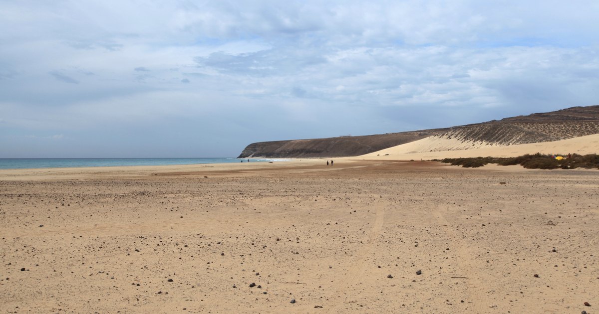
On the leeward coast of the Jandía peninsula, Sotavento unfolds for miles of sand and, at high tide, a huge flat lagoon that hosts the PWA World Cup every summer. Powerful trade winds and turquoise water: the most renowned flat-water spot in the Canary Islands.
GlissEvolution practical guide · check conditions and markings on the day of your session.
Conditions
The lagoon and the beach
At high tide, the lagoon behind the sandbank offers a waist-deep flat water area perfect for freestyle, foiling and learning. At low tide, you ride on the open beach, which is choppier, with small waves.
Trade winds
The north-easterly thermal breeze picks up in the afternoon and can blow very hard in July-August. The wind is consistent and reliable: Sotavento is statistically one of the most dependable spots in Europe during summer.
Riding style
Freeride and wave windsurfing, freestyle and foil kitesurfing, wing foiling: the lagoon is great for progressing, while the open beach is for advanced riders in strong winds.
Tide
Sotavento is not a Mediterranean spot: the tidal range is real, around 2.5 m during spring tides. This is what makes the spot. At high tide, water flows over the sandbank and fills the lagoon: a flat, waist-deep riding area stretching for hundreds of metres. On a falling tide, the lagoon empties, uncovering sandbanks and shrinking to a few channels of water; at low tide, you ride on the open, choppier beach. You should plan your session around high water, with a useful window of two to three hours on either side, and don't get trapped in the lagoon on the ebb tide.
Wind direction
The trade wind sets in from the north to north-east and strengthens in the afternoon due to a thermal effect, exceeding 30 knots in July and August. At Risco del Paso, the beach faces south-south-east: this trade wind is not an onshore wind but an angled, cross-offshore land breeze, accelerated and made gusty by the Jandía hills that channel it. This is precisely what makes the spot, as the sandbank cuts the chop and keeps the lagoon smooth, and it's also what requires you not to venture far out without thinking. The statistical reliability of the wind, which is real in summer, doesn't change its offshore component: it's the site's geography, not the wind strength, that determines the drift.
Safety & rules
Tide emptying the lagoon
Strong summer wind
Competition zones
Risks
Before you go: check the day’s forecast, tide and swell against what you see on site, and ask for a local briefing if you do not know the spot. Do not go out in offshore or gusty, unstable wind: if in doubt, stay on the beach or pick water where the wind blows you back to shore. Markings, local bylaws, swimming zones and protected areas always take priority over this guide.
Access & facilities
Access and launch
Access from the FV-2 along Costa Calma / Risco del Paso. Large car parks, long-standing windsurfing and kitesurfing schools on site, resort hotels nearby.
On-site services
No anemometer or webcam at this spot: you can only check the forecast once you are there. Allow a margin and do not count on a dedicated rescue service.
Around the spot
Risco del Paso
The point that separates the lagoon from the open beach: flat water on one side, waves and full wind on the other, it's the heart of the spot.
Flag Beach / Corralejo
At the other end of the island, our Flag Beach page covers the north of Fuerteventura: different exposure, different conditions.
Schools
Long-standing windsurfing and kitesurfing centres on Costa Calma, with rentals and lessons; booking is recommended in high season.
Weather data
Forecast from ECMWF IFS, 0.25° grid (about 25 km), interpolated to the exact spot coordinates. Long range extended with GFS up to fifteen days.
Contribute
On-the-ground corrections can be sent through the guide form; they are reviewed before going live.
Recommended gear
Frequently asked questions
Why is Sotavento so famous?
When is the lagoon rideable?
What level is required?
What is the best time of year?
Is a wetsuit necessary?
Nothing beats seeing it for yourself. Access, bans and riding zones change: always check the actual wind, markings, tide and local instructions before going out.
GlissEvolution guide for a world-class spot. Tides, lagoon conditions and competition zones should be checked locally on the day of your session. Official information →
Data, sources and updates
Forecast wind: ECMWF IFS HRES 9 km model, taken from the grid point of this spot · latest run used: 09/11, 06:00.
Swell: Open-Meteo marine forecast offshore of the spot, with no live buoy attached.
Weather forecasts: Open-Meteo data, CC BY 4.0 licence, aggregated from Météo-France, DWD, ECMWF, MET Norway, KNMI and ItaliaMeteo Arpae, served from our own servers.
Guide checked on by GlissEvolution team. Conditions and markings seen on site always take priority. See the official source for this spot ↗
Illustration photo: Frank Vincentz · CC BY-SA 3.0 · real photograph, cropped to 1200 × 630.